Japan is home to countless fascinating spots. “Abandoned islands that once prospered.” “Sacred islands forbidden to the general public.” “Temple-like flood control facilities beneath the capital.” These places sound like settings from RPG games. Yet they exist in real-life Japan.
This article introduces such strange and mysterious spots throughout Japan.
Okinawa Prefecture: “Aragusuku Island” – Sacred Island of Mermaid Legends
Location and Basic Information
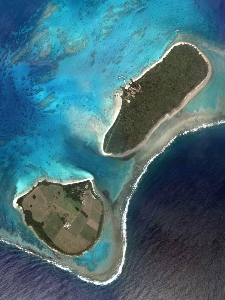
Aragusuku Island sits approximately 23 kilometers southwest of Ishigaki Island. The island consists of two separate landmasses: Kamiji Island to the northeast and Shimoji Island to the southwest. Current population totals eight residents, with seven people living on Kamiji Island and one on Shimoji Island. Visitors can only reach the island through organized tours from Ishigaki or Iriomote Island, as no regular ferry service operates. The two islands are separated by approximately 420 meters of water.
Historical Background and Origins
During the Ryukyu Kingdom period, Aragusuku Island served as a source of dugong for royal tribute. Island residents captured dugongs and processed their meat and skin for the royal court, which valued these products as medicinal remedies for childbirth. Historical records suggest approximately 700 people inhabited the island during the early 16th century. The island was officially abandoned as a permanent settlement in 1963. The island once produced famous Panari pottery, which was so valuable it could be traded for cattle.
Unique Features and Strange Phenomena
The island’s most mysterious aspect involves its “mermaid faith,” where residents worship dugongs as sacred creatures. Aragusuku Island houses the Ari Utaki, also known as the “Mermaid Shrine,” which serves as a sacred site for dugong spirits. Local legends describe how dugong swimming patterns resembled mermaids, leading to the mystical association. Multiple sacred sites called “utaki” exist throughout Kamiji Island, with many completely off-limits to outsiders. Historical accounts describe supernatural incidents when outsiders attempted to steal dugong skulls from the shrine.
Visitor Experience and Access
Tourists must join organized snorkeling or sightseeing tours from Ishigaki or Iriomote Island. The surrounding coral reefs are considered among the most beautiful in the Yaeyama Islands. Visitors can explore designated areas of Kamiji Island but must follow strict guidelines from tour guides. Multiple “god’s paths” exist throughout the island where walking is completely forbidden. Swimming and snorkeling activities focus on the pristine coral reef areas surrounding both islands.
Cultural Significance and Local Legends
The Ari Utaki represents one of four sacred sites on Kamiji Island, ranking as the second most important spiritual location. Utaki serve as sacred domains in Ryukyu spiritual tradition, representing places where gods reside. Local folklore describes tsunamis striking the community after cessation of dugong worship ceremonies. Islanders believed consuming dugong meat and skin would grant immortality. Unfortunately, dugong populations have drastically declined, and these marine mammals no longer appear in Yaeyama waters.
Photography and Documentation Rules
Photography and filming are strictly prohibited at all sacred sites, including the Mermaid Shrine. Tour participants must respect complete photography bans during sacred festivals and ceremonies. Island residents maintain absolute privacy regarding religious practices and spiritual sites. Visitors may photograph natural landscapes and designated coastal areas only. Tour guides provide clear instructions about permitted and forbidden photography zones.
Safety Precautions and Visitor Guidelines
Visitors must never explore the island independently and must always follow tour guide instructions. Signs marking “No Entry” appear throughout the island at sacred site entrances. Tourists must obtain proper permission from local authorities before visiting any cultural sites. Visitors cannot bring external garbage to the island and must preserve the natural environment. Swimming activities require supervision due to strong currents and reef protection needs.
Tourism Impact and Future Preservation
Secret festivals continue several times yearly, with former residents returning to participate in island-only ceremonies. Tourism activities must balance visitor interest with cultural preservation and resident privacy. Conservation efforts focus on protecting remaining marine ecosystems where dugongs once thrived. Local communities work to maintain traditional spiritual practices while managing sustainable tourism. The extremely small permanent population creates unique challenges for cultural continuity and island maintenance.
How to Access Aragusuku Island (Panari Island)
Basic Route
Fly to Ishigaki Island first. Take a taxi or bus from Ishigaki Airport to Ishigaki Port Remote Island Terminal. No regular ferry service operates to Aragusuku Island. You must join an organized tour from Ishigaki Island or Iriomote Island.
Travel Time
Airport to Terminal: Taxi 25 minutes (¥3,000-3,500) / Bus available (¥500)
Terminal to Aragusuku: Approximately 50 minutes by tour boat
Booking Tours
Tours depart from Ishigaki Port Remote Island Terminal. Book through local tour companies specializing in Panari Island visits. Tours typically include round-trip boat transportation, guided island walk, and lunch. Advance reservation is strongly recommended, especially during peak seasons.
Important Notes
No shops or facilities exist on the island
Sacred sites (utaki) are strictly off-limits to visitors
Follow your guide’s instructions at all times
Bring food and drinks from Ishigaki Island
Tours may be canceled due to weather or sea conditions
Photography is prohibited at sacred sites and during certain festivals
Overnight stays require advance arrangement with limited island accommodations
What to Prepare
Confirm tour schedule before departure day
Respect cultural restrictions and no-entry zones
Pack necessary supplies as island has no stores
Check weather forecast and be prepared for cancellations
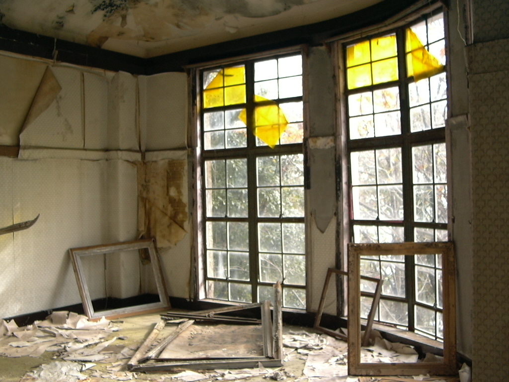
Maya Tourist Hote(Hyogo Prefecture)-The Queen of Ruins on the Mountain
コンピュータが読み取れる情報は提供されていませんが、Okc~commonswikiだと推定されます(著作権の主張に基づく) – コンピュータが読み取れる情報は提供されていませんが、自分の作品だと推定されます(著作権の主張に基づく), CC 表示-継承 3.0, https://commons.wikimedia.org/w/index.php?curid=1056460による
Hyogo Prefecture: “Maya Kanko Hotel” – The Queen of Ruins
Location and Basic Information
Maya Kanko Hotel stands abandoned on the middle slopes of Mount Maya in Nada Ward, Kobe City, Hyogo Prefecture. The hotel sits approximately 700 meters above sea level, offering commanding views of Kobe city and Osaka Bay. Access requires hiking through mountain trails, as the original cable car service no longer operates to the hotel location. The building measures four stories in height with Art Deco architectural styling. Current entry to the structure is completely prohibited due to safety concerns and cultural preservation requirements.
Historical Background and Origins
Construction began in 1929 under the Maya Cable Railway Company as a welfare facility called “Maya Club.” The hotel officially opened in November 1929, designed by renowned Kobe architect Imanishi Otsukichi. Originally conceived as employee recreational facilities, the building transformed into a luxury mountain resort targeting affluent tourists. The hotel earned the prestigious nickname “Orient’s Premier Mountain Hotel” during its golden era. Multiple name changes occurred throughout its history, including Maya Hotel, Maya Mountain Hot Spring Hotel, and finally Maya Kanko Hotel after post-war renovations.
Unique Features and Strange Phenomena
The abandoned hotel earned its famous moniker “Queen of Ruins” due to its hauntingly beautiful decay. Art Deco architectural elements remain visible throughout the deteriorating structure, creating an otherworldly atmosphere. The building’s European mountain resort design features distinctive curved balconies and geometric patterns characteristic of 1920s modernist architecture. Photographers and urban explorers describe the hotel as possessing an ethereal quality, with sunlight filtering through broken windows creating dramatic light effects. The structure’s gradual surrender to nature exemplifies the aesthetic concept of mono no aware, the beauty of transience.
Visitor Experience and Access
Currently, all public access to the hotel interior is strictly forbidden for safety and preservation reasons. Organized guided tours occasionally provide external viewing opportunities during special cultural heritage events. The surrounding mountain trails remain accessible, allowing visitors to observe the building’s exterior from designated viewpoints. Professional photography requires special permits from local authorities and heritage organizations. The Maya Ropeway provides transportation to nearby Mount Maya summit, offering distant views of the abandoned hotel structure.
Cultural Significance and Local Legends
Maya Kanko Hotel achieved national recognition in 2021 as a Registered Tangible Cultural Property, marking rare heritage status for a ruined building. The hotel represents a significant example of Japan’s prewar mountain resort culture and modernist architectural movement. Local folklore attributes supernatural phenomena to the abandoned structure, though these stories lack factual foundation. The hotel symbolizes the rise and fall of Japan’s luxury tourism industry during the early 20th century. Cultural preservationists debate balancing heritage protection with public access and urban exploration interests.
Photography and Documentation Rules
Photography inside the hotel building is completely prohibited due to structural instability and trespassing laws. External photography from public areas requires no special permissions but must respect private property boundaries. Professional photography projects require advance coordination with Kobe City cultural affairs departments and building owners. Drone photography faces strict regulations due to the mountain location and nearby residential areas. Social media documentation should avoid encouraging illegal entry or unsafe exploration activities.
Safety Precautions and Visitor Guidelines
The building structure suffers from severe deterioration, making interior access extremely dangerous due to floor collapse risks. Visitors must never attempt unauthorized entry, as prosecution for trespassing occurs regularly. Mountain hiking requires proper footwear and weather awareness, particularly during rainy seasons when trails become treacherous. Emergency services access to the remote location is limited, emphasizing the importance of following safety guidelines. Wildlife encounters, including wild boars and venomous snakes, present additional risks in the surrounding forest areas.
Tourism Impact and Future Preservation
Recent heritage designation has sparked renewed interest in sustainable tourism development around the Maya Kanko Hotel site. Local authorities balance preservation requirements with growing visitor demand for guided tours and cultural experiences. Virtual reality projects and digital preservation initiatives provide alternative access methods for interior exploration. The hotel’s cultural significance continues growing among architecture enthusiasts and heritage tourism advocates. Future plans may include limited restoration work to stabilize the structure while maintaining its ruined aesthetic character.
How to Access Maya Kanko Hotel
Important Notice
The hotel building is strictly off-limits. Entry is permitted only through special guided tours. Unauthorized access is prohibited and monitored by security systems.
Basic Route
Take public transportation to Kobe city center (JR Rokkomichi Station or Hankyu Oji-koen Station). Transfer to Kobe City Bus heading to Maya Cable Station (lower station). From Maya Cable Station, take the Maya Viewline (cable car + ropeway system) to Niji-no-Eki Station.
Maya Viewline Details
Cable Car: Maya Cable Station → Niji-no-Eki Station (5 minutes)
Transfer: At Niji-no-Eki Station to ropeway
Ropeway: Available to Hoshi-no-Eki Station (upper station)
Total Time: Approximately 15-25 minutes from base to peak
Operations: Service every 20 minutes during regular hours
Viewing the Hotel
The former Maya Kanko Hotel is visible from Niji-no-Eki Station. The ropeway provides the best aerial view of the entire building. Direct access to the hotel grounds is forbidden due to structural deterioration and safety concerns.
Guided Tours
Special viewing tours operate occasionally through organized programs. Tours typically gather at Niji-no-Eki Station and require advance registration. Cable car fare is separate from tour fees. Check official websites for current tour schedules and availability.
Important Restrictions
No parking available at the hotel site
Maya Viewline closed every Tuesday (or next day if holiday)
Winter maintenance closure for approximately 2 weeks annually
Hiking trails exist but are uncertain and potentially dangerous
Unauthorized entry is illegal and actively monitored
Building interior is extremely hazardous due to deterioration
What to Know
Tours provide helmets and safety equipment
Photography permitted only in designated areas during tours
Mountain hiking requires proper footwear and weather awareness
Emergency services have limited access to the remote location
Respect the cultural property status and preservation efforts
Hashima island(Gunkanjima)(Nagasaki prefecture)-A ruined artificial island
Koji 12 – 投稿者自身による著作物, CC 表示-継承 4.0, https://commons.wikimedia.org/w/index.php?curid=97262075による
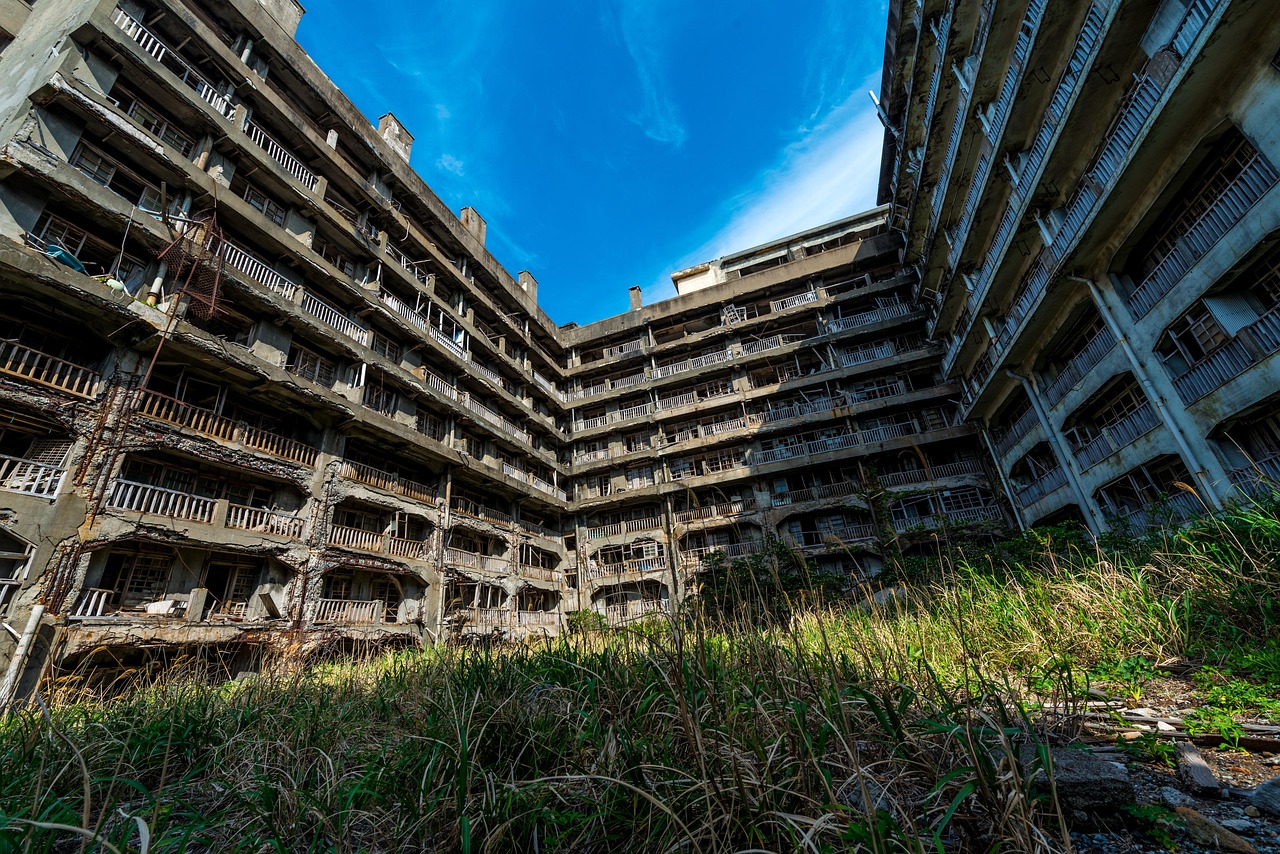
Nagasaki Prefecture: “Hashima Island (Gunkanjima)” – Former Prosperous Artificial Island Now in Ruins
Location and Basic Information
Hashima Island, commonly known as Gunkanjima (Battleship Island), sits approximately 18.5 kilometers southwest of Nagasaki Port in Nagasaki Prefecture. The island measures 6.3 hectares in total area, created through extensive land reclamation around the original natural reef. Access requires organized boat tours departing from Nagasaki Port, with journey time approximately 30-40 minutes depending on weather conditions. The island reaches 480 meters in length and 160 meters in width at its maximum points. Current population stands at zero, as the island has remained completely uninhabited since 1974.
Historical Background and Origins
Historical records first mention Hashima Island during the Edo period as a small reef known for coal deposits. Full-scale coal mining operations began in 1890 under Mitsubishi Corporation ownership, which acquired mining rights in 1890. The company initiated massive land reclamation projects and infrastructure development to support expanding mining operations. Peak population reached 5,259 residents in 1959, making it the world’s most densely populated place at that time. Mitsubishi built Japan’s first reinforced concrete apartment buildings on the island during the Taisho period to accommodate growing worker populations.
Unique Features and Strange Phenomena
The island earned its “Battleship Island” nickname due to its distinctive silhouette resembling a military warship when viewed from the sea. Concrete apartment buildings rise dramatically from the surrounding seawalls, creating an otherworldly urban landscape on the tiny artificial island. The 30-story apartment building, constructed in 1916, represented cutting-edge residential architecture for its time. Abandoned buildings now stand as haunting monuments to rapid industrialization and subsequent decline. The contrast between the island’s former bustling community life and current desolate atmosphere creates a uniquely melancholic atmosphere that captivates visitors.
Visitor Experience and Access
Tourist boats operate from Nagasaki Port offering approximately 3-hour round-trip excursions including 30-40 minutes on-island exploration time. Weather conditions frequently cancel tours due to rough seas and safety concerns around the exposed island location. Visitors can explore only designated walkways covering less than 10% of the total island area, with most buildings completely off-limits. Professional tour guides provide detailed historical commentary about mining operations, daily life, and architectural significance. The visitor center features digital museum experiences allowing virtual exploration of restricted areas.
Cultural Significance and Local Legends
Hashima Island gained UNESCO World Heritage status in 2015 as part of “Sites of Japan’s Meiji Industrial Revolution: Iron and Steel, Shipbuilding and Coal Mining.” The island symbolizes Japan’s rapid modernization during the Meiji period and the transition from traditional to industrial society. Local stories describe the island’s complete self-sufficiency, featuring schools, hospitals, temples, movie theaters, and pachinko parlors within its compact urban environment. Former residents recall both the hardships of mining life and the strong community bonds formed in the isolated island setting. The island represents both technological achievement and the environmental costs of industrial development.
Photography and Documentation Rules
Photography is permitted only within designated visitor areas and walkways, with strict prohibitions against entering restricted zones for better angles. Drone photography requires special permits from Nagasaki City authorities and faces significant restrictions due to safety and heritage preservation concerns. Professional photography projects must obtain advance permissions from multiple agencies including the city government and heritage organizations. Social media sharing should avoid encouraging dangerous exploration attempts or trespassing in prohibited areas. Weather conditions often limit photography opportunities due to sea spray and strong winds.
Safety Precautions and Visitor Guidelines
Building deterioration creates constant falling debris risks, requiring visitors to wear hard hats provided by tour operators during island exploration. Weather cancellations occur frequently, with tours suspended during high winds, rough seas, or heavy precipitation. Medical facilities are completely absent on the island, emphasizing the importance of following all safety guidelines and staying within designated areas. Emergency evacuation procedures exist but face significant challenges due to the island’s remote location and limited landing facilities. Visitors with mobility limitations face significant challenges due to uneven terrain and absence of accessibility infrastructure.
Tourism Impact and Future Preservation
Tourist numbers have grown dramatically since heritage designation, with over 300,000 annual visitors creating both economic benefits and preservation challenges. Ongoing structural deterioration requires careful balance between public access and building conservation efforts. Digital preservation projects document the island’s current state while providing alternative exploration methods for restricted areas. International tourism promotion has transformed the former industrial site into one of Japan’s most recognizable heritage destinations. Future management plans address sustainable tourism development while protecting the site’s historical integrity and ensuring visitor safety.
How to Access Hashima Island (Gunkanjima)
Important Notice
No individual access is permitted to Hashima Island. You must join an organized tour boat from Nagasaki Port. Landing depends on weather conditions and is canceled approximately 30-40% of the time.
Basic Route
Step 1: Reach Nagasaki City
From Nagasaki Airport: Take limousine bus to downtown Nagasaki (approximately 45 minutes to 1 hour)
From JR Nagasaki Station: Use streetcar or walk to port area
Step 2: Go to Nagasaki Port
Tours depart from Nagasaki Port Terminal or Tokiwa Terminal. Both locations are 10-15 minutes from JR Nagasaki Station by streetcar or bus.
Step 3: Join Tour Boat
Multiple tour companies operate cruises to Hashima Island:
Gunkanjima Concierge
Yamasa Kaiun
Gunkanjima Landing Cruise
Seaman Shokai
Takashima Kaiun
Tour Details
Duration
Total tour time: 2.5-3 hours round trip
Boat journey: 40-50 minutes each way
Island visit: 30-45 minutes (when landing is possible)
Tour Schedule (Example)
Arrive at terminal 30 minutes before departure
Board tour boat at Nagasaki Port
Cruise past Iojima Island toward Hashima
Circle the island by boat
Land at pier (weather permitting)
Guided walking tour on designated paths
Return to Nagasaki Port
Landing Conditions
Weather Restrictions
Landing requires calm sea conditions with wave height below 0.5 meters at Iojima offshore measuring station. Annual landing success rate is approximately 60-70%. Even when seas appear calm, landing may be prohibited for safety reasons.
Viewing Area Restrictions
Island exploration is limited to designated walkways for safety. Visitors can view former residential areas and mining facilities from observation paths. All visitors must follow guide instructions and stay within permitted zones.
Booking Information
Reservation
Advance booking is strongly recommended. Tours fill quickly during peak seasons. Online reservations available through company websites.
Tour Companies Contact
Check official tour company websites for:
Current schedules and availability
Pricing and ticket options
Boarding location details
Cancellation policies
Important Restrictions
No individual boat access permitted
Landing not guaranteed due to weather
Exploration limited to designated walkways only
Guided tours mandatory on the island
Hard hats provided and required during island visit
No touching buildings or entering restricted areas
What to Prepare
Confirm departure location with your tour company
Arrive 30 minutes before departure time
Check weather forecast before tour day
Wear comfortable walking shoes
Bring sun protection and water
Understand that landing is not guaranteed
Transportation from Nagasaki Station
To Port Terminals
Streetcar: Ride to Ohato stop (Big Port) or nearby stations
Bus: Various routes serve port area
Taxi: Approximately 10-15 minutes
Walking: Possible but 20-30 minutes depending on terminal
UNESCO World Heritage Site
Hashima Island is part of “Sites of Japan’s Meiji Industrial Revolution: Iron and Steel, Shipbuilding and Coal Mining” designated in 2015. Tours provide historical context about the island’s role in Japan’s industrial development.
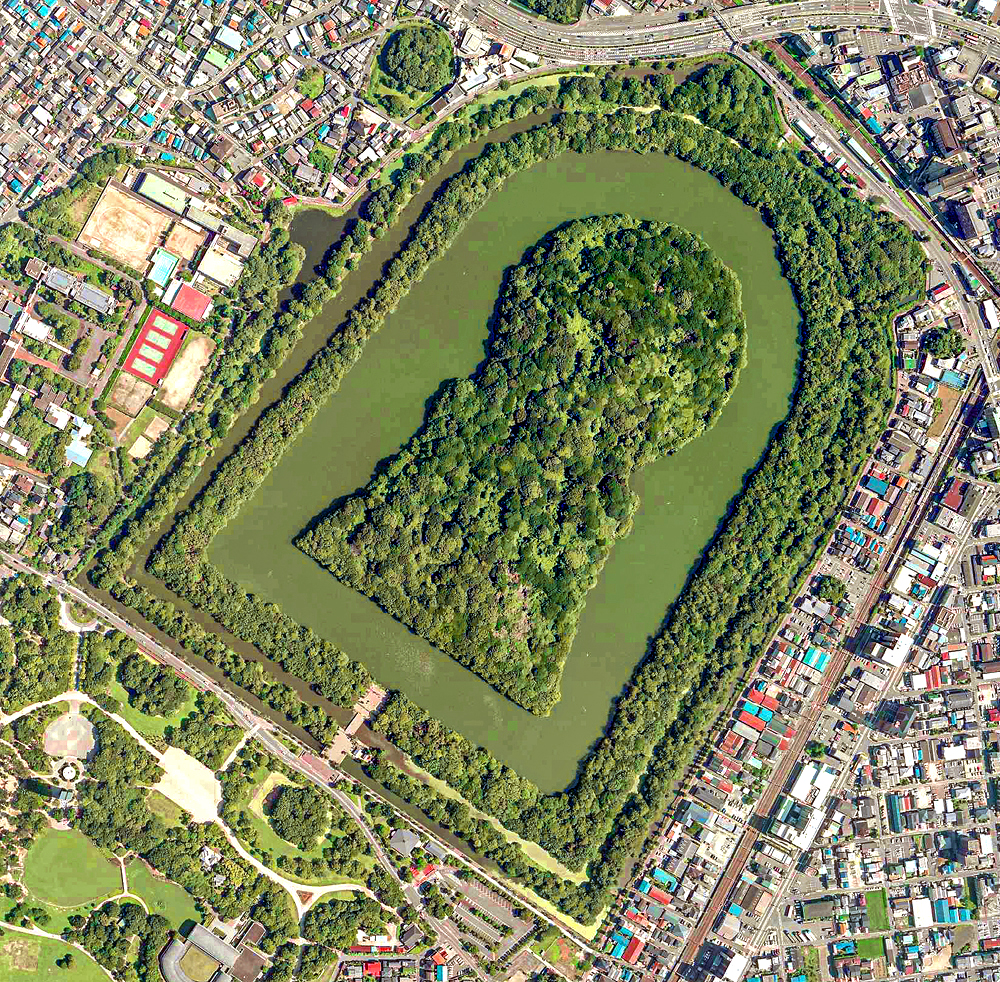
The Emperor Nintoku Tomb sits in Daisen-cho, Sakai Ward, Sakai City, Osaka Prefecture, representing Japan’s largest keyhole-shaped burial mound. The tomb measures approximately 486 meters in total length, with the circular rear section reaching 249 meters in diameter and 35.8 meters in height. Three concentric moats and embankments surround the massive structure, creating a total area of approximately 464,000 square meters including water features. The Imperial Household Agency officially manages the site as “Mozu-no-mimihara-no-naka-no-misasagi” and restricts all interior access. Visitors can access the 2.8-kilometer walking path that encircles the outer perimeter of the tomb complex.
Historical Background and Origins
Archaeological evidence suggests construction occurred during the mid-5th century CE, specifically between 425-450 CE during Japan’s Kofun period peak. The Imperial Household Agency designates this tomb as Emperor Nintoku’s final resting place, though scholarly debate continues regarding the actual occupant’s identity. Construction required several decades and employed thousands of workers, demonstrating the sophisticated social organization and engineering capabilities of ancient Japanese society. The tomb represents the culmination of keyhole-shaped burial mound development during Japan’s ancient imperial period. Historical records indicate the site served as a model for subsequent imperial tomb construction throughout the region.
Unique Features and Strange Phenomena
The distinctive keyhole shape, unique to Japanese burial culture, combines a square front section with a circular rear portion, creating an unmistakable silhouette visible from aerial views. The tomb ranks among the world’s three largest burial monuments alongside China’s First Emperor Mausoleum and Egypt’s Great Pyramid of Giza. Numerous smaller satellite tombs called “baizuka” surround the main structure, illustrating the hierarchical relationships within ancient Japanese royal courts. The triple-moat system creates distinctive acoustic phenomena, with sounds echoing differently across the water surfaces during various weather conditions. Seasonal changes transform the heavily forested tomb into a living monument, displaying different colors and atmospheric effects throughout the year.
Visitor Experience and Access
Public access remains limited to designated walking paths along the outer perimeter, providing close views of the moat system and forested burial mound. The complete circuit requires approximately one hour of steady walking along well-maintained pathways suitable for all fitness levels. Nearby Daisen Park offers additional recreational facilities and enhanced viewing opportunities from elevated positions. The Sakai City Hall observation lobby provides panoramic aerial views of the entire tomb complex from the 21st floor. Professional guided tours operate regularly, offering detailed historical commentary and cultural context about the burial complex and surrounding area.
Cultural Significance and Local Legends
UNESCO recognized the tomb as part of the “Mozu-Furuichi Kofun Groups” World Cultural Heritage Site in July 2019, acknowledging its outstanding universal value. The designation encompasses 49 burial mounds across three cities, representing the largest concentration of keyhole-shaped tombs globally. Local folklore describes supernatural protections surrounding the tomb, with stories of mysterious phenomena occurring when individuals attempt unauthorized access. The site symbolizes the emergence of centralized political authority in ancient Japan and the cultural exchange between Japanese and continental Asian civilizations. Modern archaeological research continues revealing insights about ancient Japanese society, technology, and spiritual beliefs.
Photography and Documentation Rules
Photography is permitted only from designated public areas along the outer perimeter walkway and nearby viewing locations. Aerial photography requires special permits from both the Imperial Household Agency and local aviation authorities due to restricted airspace regulations. Professional photography projects must coordinate with multiple agencies including Sakai City cultural affairs and heritage preservation departments. Social media documentation should respect the sacred nature of the imperial burial site and avoid promoting unauthorized access attempts. The Sakai City Museum provides official historical photographs and detailed documentation for research and educational purposes.
Safety Precautions and Visitor Guidelines
All attempts to enter the tomb’s interior or climb the outer embankments are strictly prohibited under Japanese law and cultural protocol. Visitors must remain on designated pathways at all times, as the surrounding moats contain deep water and unstable edges. Weather conditions can create slippery surfaces along walking paths, particularly during rainy seasons and winter months. Emergency services maintain regular patrols, but visitors should report any safety concerns immediately to designated contact points. Respect for the sacred nature of imperial burial sites requires appropriate behavior and adherence to all posted regulations.
Tourism Impact and Future Preservation
World Heritage designation has significantly increased international visitor numbers, creating both opportunities and preservation challenges for local authorities. Sustainable tourism initiatives balance public access with long-term conservation requirements for this irreplaceable archaeological site. Digital preservation projects document the tomb’s current condition while providing virtual exploration opportunities for restricted areas. Educational programs emphasize the tomb’s historical significance and Japan’s responsibility for protecting this ancient cultural legacy. Future management plans address climate change impacts, urban development pressures, and growing tourism demand while maintaining the site’s integrity.
How to Access Emperor Nintoku Tomb (Daisen Kofun)
By Public Transportation
Train Access
Take JR Hanwa Line to Mozu Station. Walk approximately 8 minutes to the worship area and main entrance. This is the most common route. Alternatively, take Nankai Koya Line to Mikunigaoka Station. Walking access is also available from this station.
Bus Access
Take a bus to Sakai City Museum stop. Walk north from the museum to reach the worship area. The walking distance is approximately 5-10 minutes.
By Car
Highway Access Exit at Sakai Exit from Hanshin Expressway. Alternatively, exit at Ohama Exit from Wangan Line. Follow signs toward Daisen Park area.
Parking Facilities Daisen Park No. 3 Parking Lot (formerly Nintoku Mausoleum Parking Lot) is available near the tomb. Additional parking is available at other Daisen Park parking lots. Parking fees apply: ¥200 for first 2 hours, ¥100 per additional hour, maximum ¥600 for 5+ hours. Total capacity exceeds 400 vehicles across all parking areas.
Important Information
The tomb’s interior is not open to the public. Visitors can view the tomb from the worship area on the south side. A 2.8-kilometer walking path circles the entire tomb complex. Allow approximately one hour for the complete circuit.
Metropolitan Area Outer Underground Discharge Channel(Saitama Prefecture)-Modern Underground Temple
日本語版ウィキペディアのDddecoさん – 原版の投稿者自身による著作物, CC 表示-継承 3.0, https://commons.wikimedia.org/w/index.php?curid=8322976による
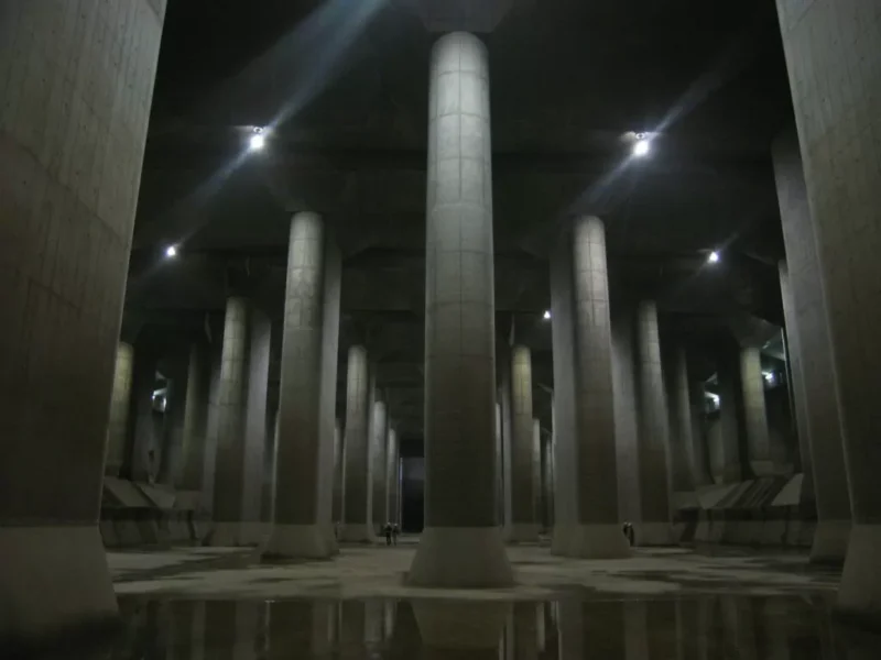
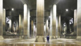
Saitama Prefecture: “Metropolitan Area Outer Underground Discharge Channel” – World’s Largest Underground Temple
Location and Basic Information
The Metropolitan Area Outer Underground Discharge Channel operates beneath Kasukabe City, Saitama Prefecture, approximately 50 meters underground along National Route 16. The facility extends 6.3 kilometers in total length, connecting five rivers through massive underground tunnels and chambers. The main pressure-adjusting tank measures 177 meters long, 78 meters wide, and 18 meters high, supported by 59 enormous concrete pillars. Access requires joining organized tours departing from the Ryukyu-kan Underground Exploration Museum located at the facility entrance. Tours operate year-round but face frequent cancellations during heavy rainfall when the system activates for flood control operations.
Historical Background and Origins
Construction began in 1992 to address recurring flood disasters affecting the greater Tokyo metropolitan area, particularly low-lying regions surrounded by major rivers. The project required 14 years to complete, officially opening in 2006 as the world’s largest underground discharge facility. Engineering challenges included excavating beneath densely populated urban areas while maintaining surface infrastructure and transportation networks. The facility cost approximately 230 billion yen to construct, representing one of Japan’s most ambitious civil engineering projects. Multiple government agencies collaborated on the design, incorporating cutting-edge tunnel boring technology and advanced pump systems.
Unique Features and Strange Phenomena
The pressure-adjusting tank earned the nickname “Underground Temple” due to its cathedral-like atmosphere created by 59 towering concrete columns arranged in perfect symmetrical rows. Each pillar weighs approximately 500 tons and prevents the massive underground chamber from floating due to groundwater pressure. The facility can discharge over 200 cubic meters of water per second through four massive pumps during flood events. Advanced sensor systems automatically monitor water levels across connected rivers, triggering emergency operations within minutes of rising flood conditions. The underground tunnels create unique acoustic phenomena, with sounds echoing dramatically through the vast concrete chambers during both operational and maintenance periods.
Visitor Experience and Access
Multiple tour options accommodate different interests and physical capabilities, ranging from 55-minute Underground Temple tours to comprehensive adventure experiences lasting several hours. The standard tour includes descending 116 steps to reach the main pressure-adjusting chamber and exploring designated observation platforms. Professional guides explain flood control operations, engineering principles, and the facility’s role in protecting metropolitan Tokyo from water disasters. Photography is permitted in designated areas, though flash photography restrictions apply to preserve the atmospheric lighting effects. Advanced reservations are mandatory due to extremely high demand, with bookings opening one month in advance and filling rapidly.
Cultural Significance and Local Legends
The facility serves as a powerful symbol of Japan’s engineering prowess and commitment to disaster preparedness following decades of flood-related tragedies. Popular culture has embraced the Underground Temple aesthetic, featuring the facility in numerous films, television dramas, and promotional materials. The structure represents the intersection of practical infrastructure and unintentional architectural beauty, demonstrating how functional design can create inspiring spaces. Local communities express pride in hosting this world-renowned engineering achievement while benefiting from enhanced flood protection. The facility challenges traditional concepts of infrastructure visibility, proving that essential urban systems can remain hidden while serving millions of residents.
Photography and Documentation Rules
Photography is permitted within designated areas of the pressure-adjusting tank using personal cameras and smartphones without flash or tripods. Professional photography requires advance coordination with facility management and may face restrictions during operational periods. Video recording follows similar guidelines, with emphasis on respecting other tour participants and maintaining safety protocols. Social media sharing is encouraged to promote flood prevention awareness, though content should accurately represent the facility’s primary disaster prevention purpose. Special media events occasionally provide enhanced access for journalists and educational content creators.
Safety Precautions and Visitor Guidelines
All visitors must wear provided safety helmets throughout underground sections due to potential falling debris and low-clearance areas. The facility maintains strict age restrictions, requiring participants to be elementary school age or older due to physical demands and safety concerns. Tours face immediate cancellation when flood conditions require system activation, prioritizing public safety over tourism activities. Emergency evacuation procedures include multiple exit routes and communication systems, though visitors should understand the remote underground location limits immediate medical response. Physical fitness requirements include ability to navigate stairs, uneven surfaces, and extended walking periods in humid underground conditions.
Tourism Impact and Future Preservation
The facility attracts over 100,000 annual visitors, generating significant tourism revenue while raising flood prevention awareness among domestic and international audiences. Educational programs target school groups, engineering professionals, and disaster preparedness advocates, expanding the facility’s impact beyond entertainment tourism. Sustainable tourism practices balance public access with operational requirements, ensuring flood control capabilities remain uncompromised by visitor activities. Future developments may include virtual reality experiences and expanded museum facilities to accommodate growing demand while protecting critical infrastructure. International recognition has established the facility as a model for combining essential urban infrastructure with public education and tourism opportunities.
How to Access Metropolitan Area Outer Underground Discharge Channel
Important Notice
Advance reservation is required for all tours. Tours may be canceled when the facility operates during heavy rainfall. The Underground Temple (pressure-adjusting tank) cannot be viewed during pump operations.
Location and Facility Information
Address: 720 Kamikanasaki, Kasukabe City, Saitama Prefecture (within Showa Pumping Station). The Ryukyu-kan (Underground Exploration Museum) serves as the visitor center and tour departure point. Tour times operate from 10:00 to 16:00, with some tours ending at 17:00. Museum hours are 9:30-16:30 (last entry 16:00).
Closed Days
Mondays and year-end/New Year holidays. On Mondays, entry may be permitted only for tour participants.
By Public Transportation
Train Access Take Tobu Urban Park Line (formerly Tobu Noda Line) to Minami-Sakurai Station. This is the nearest station to the facility.
From Minami-Sakurai Station
Walking: Approximately 25 minutes (2.3 km)
Taxi: Approximately 7 minutes (around ¥1,300)
From Kasukabe Station
Take a taxi from Kasukabe Station East Exit. Journey takes approximately 20 minutes.
Community Bus
“Haru Bus” (Kasukabe City Community Bus) operates from Minami-Sakurai Station North Exit. Service is limited with restricted operating days and times. Bus stop “Ryukyu-kan” is located directly at the facility (1-minute walk). IC cards are accepted on the bus.
By Car
Highway Access Routes
From Ken-O Expressway “Satte IC” or “Goka IC”: Approximately 30 minutes, 15 km
From Tohoku Expressway “Iwatsuki IC”: Via Route 16 toward Noda, approximately 30 minutes, 17 km
From Joban Expressway “Kashiwa IC”: Via Route 16 toward Noda, approximately 40 minutes, 20 km
Parking Facilities Free parking for approximately 50 private vehicles available. For group visits by chartered bus (micro, medium, or large buses), declare the number of buses when making reservations. Bus parking fee is ¥2,000 per vehicle.
GPS/Navigation NotesNavigation systems may not locate the facility correctly by name or phone number. Use the address “720 Kamikanasaki, Kasukabe City, Saitama” or Map Code “3 892 263*11” for accurate directions.
Reservation Information Book tours through the official website or by phone (048-747-0281, 9:00-16:30). Online reservations are recommended as phone lines have limited capacity. Tours fill quickly, especially during peak seasons.


コメント